Datei:January 2009 Bay of Biscay storm tracker.png
Es ist keine höhere Auflösung vorhanden.
January_2009_Bay_of_Biscay_storm_tracker.png (650 × 500 Pixel, Dateigröße: 173 KB, MIME-Typ: image/png)
| Dieses Medium wird direkt von Wikimedia Commons aus eingebunden. Quellenangaben und Lizenzbedingungen werden von der dortigen Dateibeschreibungsseite direkt hier angezeigt (siehe unten). |
Beschreibung
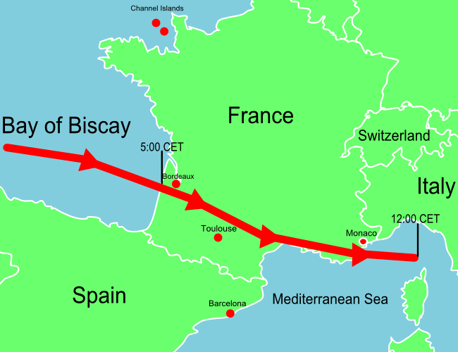
| Beschreibung | A map of Europe showing the location of the January 2009 Mediterranean storm. The red line shows the track of the storm. |
| Datum | |
| Quelle | Self-made losely based upon BBC map, but not a derivitive work. |
| Urheber | Jolly Janner |
| Andere Versionen | The original vector version |
Lizenz
| Ich, der Urheberrechtsinhaber dieses Werkes, veröffentliche es als gemeinfrei. Dies gilt weltweit. In manchen Staaten könnte dies rechtlich nicht möglich sein. Sofern dies der Fall ist: Ich gewähre jedem das bedingungslose Recht, dieses Werk für jedweden Zweck zu nutzen, es sei denn, Bedingungen sind gesetzlich erforderlich. |
Dateiversionen
Klicke auf einen Zeitpunkt, um diese Version zu laden.
| Version vom | Vorschaubild | Maße | Benutzer | Kommentar | |
|---|---|---|---|---|---|
| aktuell | 16:07, 25. Jan. 2009 | 650 × 500 (173 KB) | Jolly Janner | Added Channel Islands and labeled Switzerland | |
| 03:11, 25. Jan. 2009 | 650 × 500 (163 KB) | Jolly Janner | {{Information |Description=A map of Europe showing the location of the January 2009 Mediterranean storm. The red line shows the track of the storm. |Source=Self-made losely based upon [http://newsimg.bbc.co.u |
Dateiverwendung
Die folgende Seite verwendet diese Datei:
Globale Dateiverwendung
Die nachfolgenden anderen Wikis verwenden diese Datei:
- Verwendung auf en.wikipedia.org
- Verwendung auf en.wikinews.org
- Verwendung auf es.wikipedia.org
- Verwendung auf eu.wikipedia.org
- Verwendung auf fr.wikipedia.org
- Verwendung auf pl.wikipedia.org
- Verwendung auf pl.wikinews.org
- Verwendung auf zh.wikipedia.org