Datei:Arab World Green.svg

Größe der PNG-Vorschau dieser SVG-Datei: 800 × 406 Pixel. Weitere Auflösungen: 320 × 162 Pixel | 640 × 325 Pixel | 1.024 × 520 Pixel | 1.280 × 650 Pixel | 2.560 × 1.299 Pixel | 940 × 477 Pixel.
Originaldatei (SVG-Datei, Basisgröße: 940 × 477 Pixel, Dateigröße: 404 KB)
| Dieses Medium wird direkt von Wikimedia Commons aus eingebunden. Quellenangaben und Lizenzbedingungen werden von der dortigen Dateibeschreibungsseite direkt hier angezeigt (siehe unten). |
Beschreibung
| Beschreibung |
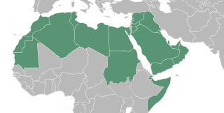
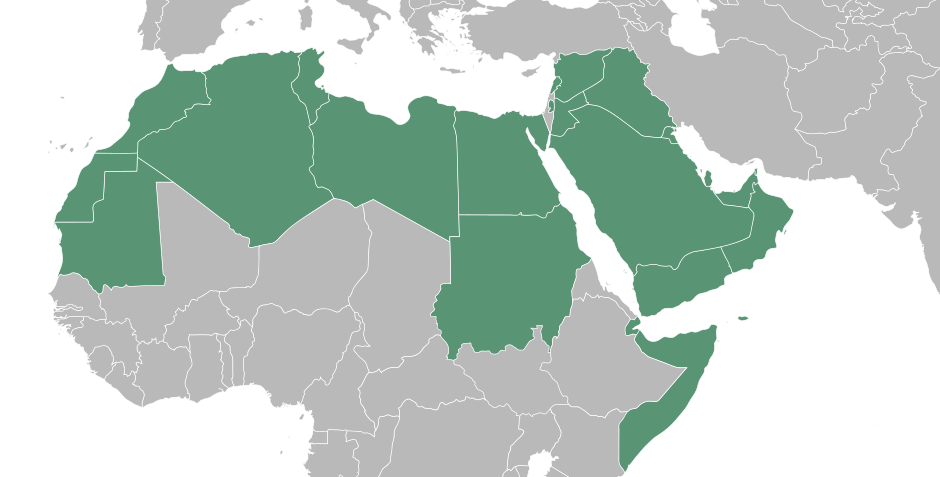
English: A map showing a portion of the Islamic world, North African country's are inhabited by the Amazigh an minority among them identified them self as Arab, in many cases it's what the feel despite not having an Semitic Middle eastern DNA. Egyptians are not Arabian either, but you have to understand they became Arab by culture. Last but not least the Middle East where the Arab originated from. The Islamic world has so many different race's that it is impossible to talk about an Arab world while the majority of the Muslims is not of Arab decent. The Islamic world is very cultural and racial diverse. It is their religion and spiritual bond that comes with it what connects them. Because of that, it's more appropriate and polite to talk about the Islamic world because that is what connects them. Besides that there is no Arabian Empire that rules over the whole Islamic world.
العربية: خريطة العالم العرب
ქართული: არაბული სამყაროს რუკა |
| Datum | |
| Quelle |
Diese Landkarte enthält Elemente, die von folgender Datei entnommen oder adaptiert wurden: |
| Urheber | T.seppelt |
| Andere Versionen |
|
| SVG‑Erstellung |

Lizenz
| Ich, der Urheberrechtsinhaber dieses Werkes, veröffentliche es als gemeinfrei. Dies gilt weltweit. In manchen Staaten könnte dies rechtlich nicht möglich sein. Sofern dies der Fall ist: Ich gewähre jedem das bedingungslose Recht, dieses Werk für jedweden Zweck zu nutzen, es sei denn, Bedingungen sind gesetzlich erforderlich. |
Dateiversionen
Klicke auf einen Zeitpunkt, um diese Version zu laden.
| Version vom | Vorschaubild | Maße | Benutzer | Kommentar | |
|---|---|---|---|---|---|
| aktuell | 12:49, 3. Sep. 2022 | | 940 × 477 (404 KB) | SahinBasaran | Reverted to version as of 02:46, 3 September 2022 (UTC) |
| 12:49, 3. Sep. 2022 |  | 1.920 × 974 (311 KB) | SahinBasaran | Reverted to version as of 21:05, 2 September 2022 (UTC) | |
| 12:48, 3. Sep. 2022 |  | 2.400 × 1.218 (440 Bytes) | SahinBasaran | Reverted to version as of 21:00, 2 September 2022 (UTC) | |
| 04:46, 3. Sep. 2022 |  | 940 × 477 (404 KB) | M.Bitton | Reverted to version as of 03:34, 21 February 2016 (UTC): please don't perform tests on stable maps | |
| 23:05, 2. Sep. 2022 |  | 1.920 × 974 (311 KB) | SahinBasaran | Added Israel, Malta and Somaliland. | |
| 23:00, 2. Sep. 2022 |  | 2.400 × 1.218 (440 Bytes) | SahinBasaran | Added Israel, Malta and Somaliland. | |
| 05:34, 21. Feb. 2016 |  | 940 × 477 (404 KB) | Turnless | Fix format | |
| 22:45, 11. Apr. 2015 |  | 940 × 477 (431 KB) | T.seppelt | {{Information |Description ={{en|1=a map of the Arab World}} |Source ={{Attrib |1=BlankMap-Middle East.svg |2=NuclearVacuum }} |Author =T.seppelt |Date =2015-04-11 |Permission = |other_versions =[[:Fi... |
Dateiverwendung
Die folgenden 15 Seiten verwenden diese Datei:
- Wikinews:Archiv/Hauptseite/2011/02
- Wikinews:Pressestammtisch/Archiv/2011/Februar
- Vorlage:Portalnavigationsleiste Arabische Welt
- Portal:Arabische Welt
- Portal:Irak
- Portal:Jemen
- Portal:Libanon
- Portal:Libyen
- Portal:Saudi-Arabien
- Portal:Somalia
- Portal:Sudan
- Portal:Syrien
- Portal:Tunesien
- Portal:Vereinigte Arabische Emirate
- Portal:Ägypten
Globale Dateiverwendung
Die nachfolgenden anderen Wikis verwenden diese Datei:
- Verwendung auf af.wikipedia.org
- Verwendung auf als.wikipedia.org
- Verwendung auf arc.wikipedia.org
- Verwendung auf ar.wikipedia.org
- Verwendung auf arz.wikipedia.org
- Verwendung auf az.wiktionary.org
- Verwendung auf bg.wikipedia.org
- Verwendung auf bn.wikipedia.org
- Verwendung auf bs.wikipedia.org
- Verwendung auf de.wikipedia.org
- Verwendung auf en.wikipedia.org
- Verwendung auf en.wiktionary.org
- Verwendung auf es.wikipedia.org
- Verwendung auf fa.wikipedia.org
- Verwendung auf fa.wikiquote.org
- Verwendung auf fr.wikipedia.org
- Verwendung auf fy.wikipedia.org
- Verwendung auf gl.wikipedia.org
- Verwendung auf he.wikipedia.org
- Verwendung auf hu.wikipedia.org
- Verwendung auf hy.wikipedia.org
- Verwendung auf hyw.wikipedia.org
- Verwendung auf incubator.wikimedia.org
- Verwendung auf it.wikipedia.org
- Verwendung auf ka.wikipedia.org
- Verwendung auf nn.wikipedia.org
- Verwendung auf pa.wikipedia.org
- Verwendung auf pnb.wikipedia.org
Weitere globale Verwendungen dieser Datei anschauen.